
Muhammad Al-Idrisi was a geographer and cartographer from the 11th century who charted a world map that is very similar to the one we know today. This was a feat considering the primitive technology then and the lack of air travel. Furthermore, he was trying to map a round world in a time when many people still believed in a flat one.

This is his story of persistence and success.
A Lifelong Devotion To Cartography
Back in the early centuries, there were two main schools of cartography. The school of Balkhi drew maps of the nearby Islamic empires, which gave geopolitical and religious orientations of the region but were not very mathematical. Al-Idrisi belonged to the Ptolemaic school, who were more scientific and mathematical with their use of longitudes and latitudes.
To develop a map of the world, Al-Idrisi relied on observations from traveling merchants and formal documents written by previous explorers and geographers. As there were no instruments to measure distances then, his maps were mostly approximations where distances were marked as “a day’s journey”, “a day’s sailing”, “a palm’s length”, or even “an arrow’s shot away”.
It took him more than 15 years of referencing, checking, and mapping to attain a high level of accuracy and reliability. While his map did not clearly demarcate geopolitical boundaries (or countries as we know it), it was extremely detailed with annotated socio-political, geographical, and cultural observations. Al-Idrisi’s maps were visual representations of the world and much more – they were historical records of the Medieval times!
Producing The Most Accurate Medieval World Map
Despite his eventual success, Al-Idrisi’s was often criticized for leaving out notable geographic works of other scientists, while loosely using Greek and Arab sources that could have been biased. His works were also fairly contrarian in a flat-world era.
Al-Idrisi’s breakthrough came with King Roger II of Sicily, who employed him to develop a map of the world. The project was conducted in three phases – the first was to collect and sort through written and oral data, the second was to collate and map out the places based on longitudes and latitudes, and the last phase was to engrave these details onto a silver disc.

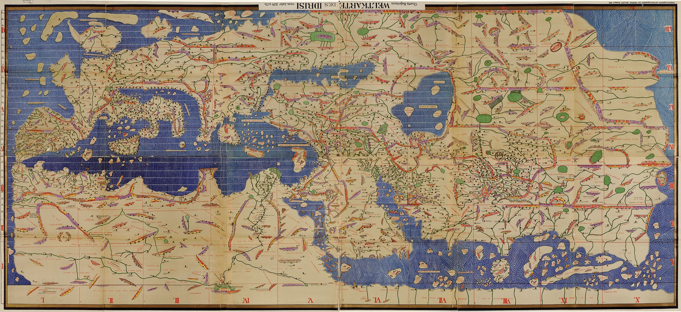
Al-Idrisi's world map with the 70 sections combined. The original map is upside-down, with the South at the top. (Source)
The whole project took over 18 years to complete, and while the final silver globe has been lost, the Tabula Rogeriana (or The Map Of Roger) survived, and remains one of the most advanced medieval world maps till today. According to the French National Library, only 10 copies of the Tabula Rogeriana exists.
The Tabula Rogeriana is a book that contains Al-Idrisi's 70 double-page sketches, which form a map of the world when pieced together. In the following centuries, geographers and explorers relied extensively on this world map and made little to no alterations to it.
Today, cartographers have also recreated this map onto a silver globe using modern-day etching techniques. The map was a success and is testament to Al-Idrisi’s legacy as a geographer and cartographer who lived ahead of his time.
Discover the Idris Ring


The Idris Ring is our salute to the wondrous works of Al-Idrisi. A luminous band of enamel wraps around the finger, interrupted only by a girdle of pavé diamonds. Available in white or black enamel, and in 18K Yellow Gold, White Gold, or Rose Gold, the Idris Ring is an effortless accessory for every occasion that can be worn alone or as a ring stack.
Complete the look with other Idris-themed jewellery like the Idris Bangle and the Idris Minor Hoop Earrings. Or check out our Voyager collection for more of such inspirational jewellery.
Sources:
The Shape of the World, According to Old Maps (Visual Capitalist)
The History Of Cartography – Cartography of aI-SharIf aI-IdrIsI (Maqbul Ahmad)
Muhammad Al-Idrisi (Environment and Ecology)
Al-Idrisi (Nat Geo)
Share:
Isabelle Eberhardt: An Adventurer Who Lived Her Nomadic Dream